Mystical latitude 00° 00’ 00” of the Mitad del Mundo
6 min read
Even though the equator line passes through 13 other countries around the globe, no other country like Ecuador exhibits this much pride in its unique geographical location at “the middle of the world” or “Mitad del Mundo”.
While the concept of the equator is based on geometry, early mapping efforts, like the one by French explorers in 1730 who was the first Geodesic (which meant the shortest line between two points on a curved surface) Mission of the French Academy of Sciences, which brought French scientists (and some Spanish naval officers) to determine the equatorial line. Which was one of the first that employed modern scientific principles and helped to define and map its location on the Earth’s surface. So, their Mission helped establish the equator’s location near Quito, Ecuador, leading to the country’s name and its association with the 0-degree latitude line.
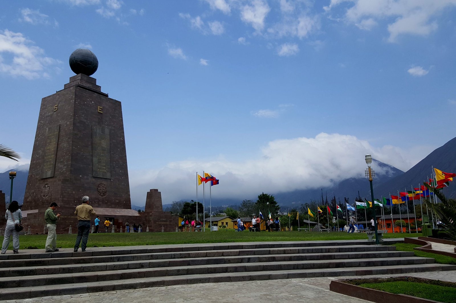
At around 20km from Quito Ecuador’s capital, a monument has been built to commemorate their mission. This official monument is impressive, you can experience the thrill of standing on the equator, visit museums and enjoy the area surrounding the monument that offers restaurants and shops, allowing you to experience the local culture. This museum provides insights into the history of geodesy and the Earth’s shape, with interactive exhibits.
Ciudad Mitad del Mundo contains other attractions such as a planetarium, a miniature model of Quito, and restaurants. On weekends, Ciudad Mitad del Mundo’s Central Plaza hosts varied musical and cultural events for tourists. Also, there are diverse local handcraft stores and local food served at several cafés along a small colonial town.
But it has been confirmed to be misplaced, approximately 200 meters from the true 0-degree latitude line certainly caused by the inaccuracy of the equipment use at that time by the first Geodesic Mission of the French Academy of Sciences compare to our actual GPS.
Fortunately, at the true 0-degree latitude, there is the private Intiñan Solar Museum that you can visited right away after your journey to the official monument. You can see several things at this museum like the shadow clock which referred as the solar clock, this stone tool was used by ancient Ecuadorian cultures to tell time. However, there aren’t any numbers on it and in lieu of two hands, a single rod protrudes from its center. The clock is divided into three sections: tuta manta, chisi, and pajta, meaning morning, afternoon, and midday. The way the sun casts a shadow on the rod is a very accurate way to tell time.
But the funny part at Intiñan Museum is at the equator line itself. While it is not as “monumental” as its misplaced counterpart, it does its job: marks the Mitad del Mundo accurately. The guide will take you through a series of demonstrations that are a result of the Coriolis effect and the equator’s weaker gravitational pull.
This Coriolis effect is caused by Earth’s rotation, deflects moving objects (like air currents, ocean currents, or even projectiles) to the right in the Northern Hemisphere and to the left in the Southern Hemisphere.
As a direct result of the Coriolis effect, in countries near the Earth’s equator, tourists are often dazzled by a demonstration of a mysterious physical phenomenon. The presenter will drain water down from a bucket of water and according from the Hemisphere you are, the water will spin counterclockwise in the Northern Hemisphere and clockwise in the Southern Hemisphere but on the equator line, the water will drain out straits through.
You can see the demonstration on this YouTube video:
However, according to Carl-Gustav Rossby meteorologist, the Coriolis force can be measured by the Rossby number for an average hurricane is 1. It is true that hurricanes tend to rotate clockwise in the Southern Hemisphere and counterclockwise in the Northern Hemisphere. But for a relatively small system like the bucket of water, the Rossby number will be more than 10000 times larger.
This observation indicates that the Coriolis force is negligible on water draining in a bathroom sink. In fact, the Rossby number predicts that the water would need to move at an almost imperceptible speed for the Coriolis force to become significant. So even though the way water swirls down the drain may be consistent, that isn’t due to the Coriolis effect. This conclusion is supported by this 2 others video showing that the water in the Northern Hemisphere rotates counterclockwise in one video but clockwise in another video. If the rotation were due to the Coriolis effect, the result would be the same in both videos.
After the interesting explanation concerning the Coriolis force, the equator is essentially the reference point from which latitude is measured (Mean latitude 00° 00’ 00”) and lies perpendicular to the Earth’s axis. The distance from the equator line to each pole is exactly the same. The equatorial bulge created by the rotation where the Earth’s diameter is wider by approximately of 42 km compare of the measure at both poles and the weaker gravitational pull (an object at the equator weighs 0.5 percent less than at the poles.) compare to poles make this spot on our planet exceptional.
Here are other facts and interesting point about Ecuador Country:
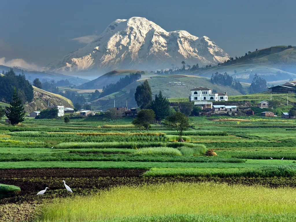
- The highest peak in Ecuador is the Mount Chimborazo situated at 1.5 degrees south of the equator, with an elevation of 6,263 meters (20,548 feet). While it is not as high above sea level as Mount Everest, its summit is farther from the Earth’s center than Everest’s summit due to the equatorial bulge created by the earth rotation.
- The highest point where the equator passes on Earth is on the southern slopes of Vulcan Cayambe in Ecuador at an elevation of 4,690 meters (15,387 ft). It’s the third highest mountain in Ecuador with 5,790 meters (18,996 feet) above sea level and is approximately 70 kilometers (43 miles) north-northeast of the “Mitad del Mundo”.
- Places along the equator are the only spots in the world where you can see the stars in both hemispheres. On a clear night, you see both the southern cross and the big dipper at the same time.
- Oblate Spheroid: The Earth is an oblate spheroid, meaning it’s wider around the equator and flattened at the poles.
- Equatorial Bulge: This bulge is caused by the centrifugal force generated by the Earth’s rotation. The equator experiences the greatest centrifugal force and therefore bulges out the most.
- Distance from the Center: Because of this bulge, points on the equator are farther from the Earth’s center than points at the poles or at higher latitudes.
- Altitude vs. Distance: It’s important to distinguish between altitude (measured from sea level) and distance from the Earth’s center.
Ecuador’s altitude makes the country’s location even more special; it is a place characterized by unrelenting sun and an unusual weather pattern because the Coriolis effect is very weak near the equator, so this feature prevents the hurricanes formation. Additionally, the Andes Mountain range and other geographical features in Ecuador can provide some protection from other natural disasters. So, all those features make Ecuador even more appealing for investment or retirement, especially when compared to other Latin American countries like Panama, Costa Rica, or Mexico.